

by Dr Catherine Porter, Lecturer in Geography, University of Limerick
![]()
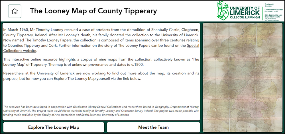
In 2013, the family of Timothy Looney, County Tipperary, donated his lifetime collection of archival material to the University of Limerick (UL). Now expertly catalogued and extant in Special Collections and Archives, Glucksman Library, The Timothy Looney Papers are rich with manuscript and printed material including photographs, books, documents and cartography detailing the histories of the Counties Tipperary and Cork.
Amongst the Papers is one large and intriguing linen-backed map (Figure 1) measuring approximately 170 cms by 266 cms, comprised of nine smaller sections (approximately 56.5cms by 88.5 cms), part of a wider collection salvaged by Looney from the demolition of Shanbally Castle in March 1960. Drawn ‘By a Scale of two Inches in one Irish Mile’, the discreetly coloured cartography depicts the Tipperary landscape at the end of the eighteenth and beginning of the nineteenth centuries. Natural features such as rivers, loughs, bogs and mountains are marked alongside the built environment and local heritage including buildings, roads and laneways. Whilst the provenance of the ‘Looney Map’ is unknown, it is dated by UL Archivist, Anna-Maria Hajba, to c.1800-1815, placing it in a pre-Ordnance Survey (OS) timeframe. The estimated dating further emphasises the map’s significance given County Tipperary never had a printed Grand Jury map.[i]

Placing the ‘Looney Map’ online
Given the collection was uncatalogued until 2019, to date, there has been little knowledge of, and limited access to, the map for research purposes. As part of an ongoing digitisation programme at Glucksman Library, the nine map sheets were recently photographed as a suite of high-resolution images for preservation and research.
To aid investigation and dissemination of the map, funding was awarded to UL Geography staff by the Faculty of Arts, Humanities and Social Sciences, UL, to construct a public-facing, interactive online resource using the ESRI ArcGISTM platform (Figure 2).
The online resource uses a side-by-side viewer interface, with the Looney Map presented on the left of the screen and the 1st Edition OS maps to the right, enabling users to freely explore the content through familiar pan and zoom functionality. Additionally it incorporates a search facility where users can more closely examine locations of interest and reveal further information on the map content via the digital point data (Figure 3).

The online viewer also aids researchers in better navigating change over time; as the user pans, zooms or searches the Looney Map, the geography in the corresponding OS map sheets shift accordingly connecting the cartography through place and time.
Initial impressions of the cartographic content
In using the resource to research the map and associated landscape, the first tantalising messages from the cartographic content emerge. Specifically, it highlights a level of disagreement between the Looney Map and the 1st Ordnance Survey that took place some forty years later; several houses marked as prominent features on the Looney Map do not appear on the OS cartography and vice versa. One example is a building named Rossfinch that is documented on the Looney map as lying approximately 3 kilometres northwest of Birdhill. In the 1850 rate book for Birdhill it is recorded as ‘House and Land’ with more than 407 acres and a Net Annual Value of £192.[ii] The same house is unnamed by the OS (although a likely match to a building is visible), and it is not listed in the Landed Estates Database (Figure 4).


Curiously, the opposite is true of Kilmastulla House, located 0.5 kilometres to the north of Rossfinch. Depicted by the OS as a prominent residence and gardens, on the Looney Map it is indicated only by the townland of the same name (Figure 5). The 1850 rate books record Kilmastulla estate as smaller in size (just exceeding 56 acres) and value (£51, 1s.) to Rossfinch. [iii]


These brief examples illustrate the possibilities of the resource in connecting cartographic collections through place and time and are a confirmation of this cartography as a vital pictorial record of landscape change and alteration to the built heritage in the county during this period. It also raises questions for further research. Given the discrepancies in the sources, the resource might aid in determining the criteria for the inclusion of ‘houses’ on early maps and assist in filling the gaps in our knowledge of map-making in Ireland at this time.[iv] Extending this research might also aid in pinpointing the date of the Looney Map and help to establish why the map was made, by whom, and its intended audience.
Conclusions
You can explore the Looney Map resource through the following link: The Looney Map of Tipperary. Comments on the resource may be forwarded to catherine.porter@ul.ie. If you would like to learn more about the creation of the resource you can freely access a related journal publication available online via e-Perimetron website.
A related public lecture will take place at Tipperary County Library, Thurles, in April 2023. Details to follow.
Acknowledgements
The project team wish to extend their gratitude to the family of Timothy Looney for the donation of their father’s archive to Glucksman Library. The research was funded by the Faculty of Arts, Humanities and Social Sciences, University of Limerick, and the resource developed by researchers based in Geography, University of Limerick.
About the Author
Dr Catherine Porter is a Lecturer in Geography at the University of Limerick. Her research interests lie in new ways to approach and analyse early maps and texts, specifically the histories of mapping Ireland. Catherine is currently the Ireland project lead for the digital humanities project, ‘OS200: Digitally Re-mapping Ireland’s Ordnance Survey Heritage’, co-funded by the Irish Research Council and the Arts and Humanities Research Council.
References
[i] Arnold Horner, ‘Patrick Leahy’s Maps of the Barony of Slieveardagh 1818 and of the Killenaule Coal District 1824’, Tipperary Historical Journal (2008), pp 51-75.
[ii] Nenagh Poor Law Union, ‘Birdhill Rate Book 1850’, Tipperary Studies Digital Archive, accessed January 26, 2023, https://www.tippstudiesdigital.ie/items/show/549, p. 16.
[iii] Ibid. p. 19
[iv] With thanks to Dr Karol Mullaney-Dignam (UL) and Dr Paul O’Brien (MIC) for their comments and insight on properties in the vicinity.
You must be logged in to post a comment.